KATIA LAMER
  • Home
  • Research Interests
    • Factors controlling boundary layer clouds
    • Linking models and observations
    • State-of-the-art cloud remote Sensing >
      • Ground-based multi-dimentional observations of clouds and precipitation
      • Spaceborne observations of shallow and low-level targets
    • Applied research - Urban meteorology and renewable energy
  • Publications
  • Media
  • Presentations
  • Contributions
  • Contact

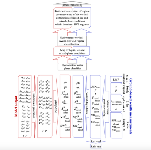
Linking Global Circulation Models (GCMs) and Ground-Based Observations

​General circulation model (GCM) evaluation using ground-based observations is complicated by inconsistencies in hydrometeor and phase definitions as well as by the scale gap between the two.
Picture

References:
- Lamer, K. and coauthors (2018). (GO)2-SIM: a GCM-oriented ground- observation forward-simulator framework for objective evaluation of cloud and precipitation phase. Geoscientific Model Development 11, no. 10: 4195-4214.

- Lamer, K (2019). Relative occurrence of liquid, ice and mixed-phase conditions within cloud and precipitation regimes: Long term ground-based observations for GCM model evaluation. PennState University dissertations


Reports:
- ARM/ASR report: Advancing the Use of ARM Observations for Large-Scale Earth System Model Development breakout session summary       07/2019
- ARM/ASR report: End-to-end Forward Simulators breakout session summary                                04/2018


Code availability:
- (GO)2-SIM and the mutlti-species subcolumn generator are not currently publicly available, contact me for more information 
​
Opportunities: 
I am looking for collaborators to implement my subcolumn generator and cloud regime and phase statistical display ideas.
​
Reports:
A breakout session was hosted at the 2019 ASR_ARM PI meeting to discuss challenges associated with using ground-based observations for large-scale model evaluation details. Presentations and report associated with this breakout session can be found at https://asr.science.energy.gov/meetings/stm/agenda/2019

Overcoming the hydrometeor and phase definition
​and accounting for instrument capabilities

To overcome inconsistencies in hydrometeor and phase definitions, I developed (GO)2-SIM, a forward-simulator designed for objective hydrometeor phase evaluation, and assess its performance over the North Slope of Alaska using a one-year simulation of the NASA GISS GCM ModelE3 global model. 

For uncertainty assessment, (GO)2-SIM employs 18 empirical relationships to convert model grid-average hydrometeor (liquid and ice, cloud and precipitation) water contents to zenith polarimetric micropulse lidar and Ka-band Doppler radar measurements producing an ensemble of 576 forward-simulation realizations. Sensor limitations are represented in forward space to objectively remove from consideration model grid cells with undetectable hydrometeor mixing ratios, some of which may correspond to numerical noise.
 
Phase classification in forward space is complicated by the inability of sensors to measure ice and liquid signals distinctly. However, signatures exist in lidar-radar space such that thresholds on observables can be objectively estimated and related to hydrometeor phase. The proposed phase classification technique leads to misclassification in fewer than 8% of hydrometeor-containing grid cells. Such misclassifications arise because, while the radar is capable of detecting mixed-phase conditions, it can mistake water- for ice-dominated layers. However, applying the same classification algorithm to forward-simulated and observed fields should generate hydrometeor phase statistics with similar uncertainty. Alternatively, choosing to disregard how sensors define hydrometeor phase leads to frequency of occurrence discrepancies of up to 40%. So, while hydrometeor phase maps determined in forward space are very different from model “reality” they capture the information sensors can provide and thereby enable objective model evaluation. 

Overcoming the scale gap

For models with sufficiently high spatial and temporal resolution to resolve individual hydrometeor layers, evaluation of model hydrometeor microphysical properties follows after reaching a common hydrometeor and water-phase definition with observations. Unfortunately, historically, the spatial resolution of GCMs has been larger than individual cloud layers such that, in addition to hydrometeor microphysical property descriptors, GCMs have additionally required fractional areal coverage descriptors that quantify the volumes occupied by hydrometeors within every model grid box.

After years of advancements, the vertical grid resolution of GCMs has now reached the tens-to-hundred-meter scale so that individual cloud layers are now vertically resolved. In addition to removing the need to track cloud vertical fractional coverage within a model grid box, this advancement eliminates in large measure the vertical scale gap between model output and observations. Current approaches do not treat Doppler observables. For the purpose of evaluating liquid and ice microphysics within ModelE3, I have worked on expanding on current approaches by proposing a new technique where reflectivity weights are used to degrade the vertical resolution of ground-based radar mean Doppler velocity and Doppler spectral width observables in order to emulate the radar radiation scattering response.

For those GCMs, like ModelE3, whose horizontal grid resolution remains on the order of hundreds of kilometers, hydrometeor horizontal fractional areal coverage must be parametrized, and a different technique is required to overcome the scale gap between model and observations in the horizontal dimension. Creating a parallel between observed and simulated hydrometeor horizontal fractional areal coverage, hereafter referred to simply as hydrometeor fraction or cloud/precipitation fraction, is challenging because a model and a sensor’s ability to characterize hydrometeor fraction differs. For sensors, the ability to detect cloud is affected, among other considerations, by the locations of the hydrometeor layers relative to the sensor. Fortunately, cloud and precipitation vertical overlap assumptions in models permit the generation of subcolumns within a GCM column of grid boxes that capture subgrid scale variability in hydrometeor horizontal and vertical distributions.

Generating subcolumns from GCM output is a multi-step process. The process involves distributing both hydrometeor horizontal fractions and hydrometeor mass mixing ratio amounts in such a way as to obey all model assumptions on hydrometeor overlap within a grid box and vertical overlap from one layer to the next. The complexity of this process increases as the number of hydrometeor species and the number of model assumptions on hydrometeor overlap become more complex. I attempted to tackle this challenge by developing a subcolumn generator capable of distributing simulated convective and stratiform cloud and precipitation fractions to produce horizontally-microphysically-homogeneous subcolumns that strictly adhere to the assumptions implemented in the microphysical scheme of the NASA GISS GCM ModelE3.

Statistically summarizing big data

​Because ground-based observations are point measurements and large-scale models simulate a domain, it is appropriate to perform a statistical comparison between the two. Statistically summarizing hydrometeor attributes while not masking compensating biases is not simple because a number of processes, both large-scale and microphysical, affect cloud and precipitation growth, lifetime and decay. Moreover, it is desirable that such simplified statistical summary maintains sufficient information to diagnose the cause of identified biases. This complexity has influenced the scope of previous model evaluation studies.

To expose regional, cloud-type, height and season specific biases I have create a regional vertically-resolved statistical summary of water phase, including ice, liquid and mixed-phase, within the context of hydrometeor vertical layering (HVL) regimes. I defined HVL regimes following a technique comparable to one used by the International Satellite Cloud Climatology Project  (ISCCP; [Rossow and Schiffer, 1991]) and similar to the cloud vertical structure approach (CVS) proposed by Rémillard and Tselioudis [2015] and Tselioudis et al. [2013]. I identified thirteen different HVL regimes by considering the vertical locations of hydrometeors across three atmospheric regions – low, middle and high – separated by defined altitude levels. However, unlike others before, I estimated, within each regime for each of 64 vertical layers, the relative frequency of occurrence of liquid, ice and mixed-phase conditions. Following this framework, I was able to objectively compare large-scale model output to observations such that observed discrepancies can be more readily attributed to large-scale dynamical and microphysical issues rather than methodological bias.
Powered by Create your own unique website with customizable templates.
  • Home
  • Research Interests
    • Factors controlling boundary layer clouds
    • Linking models and observations
    • State-of-the-art cloud remote Sensing >
      • Ground-based multi-dimentional observations of clouds and precipitation
      • Spaceborne observations of shallow and low-level targets
    • Applied research - Urban meteorology and renewable energy
  • Publications
  • Media
  • Presentations
  • Contributions
  • Contact